Garmin GPS Map 430X w/Built-In Inland Blue Chart and XM
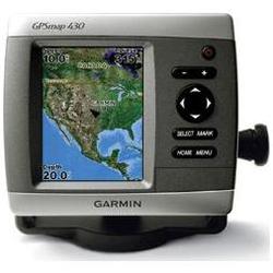

GPSMAP 430x Package Includes: * GPSMAP 430x * Built-in receiving antenna * GXM 31 Antenna * Power/data cable * Crimp connectors * Mounting bracket with tilt/swivel * Protective front cover * Owner's manual and quick reference guide The sleek 430-series Garmin plotters pack a lot of value into their space-saving formats. They feature ultra-bright 4 QVGA displays and come ready to launch right out of the box with built-in cartography, worldwide satellite imagery, and a new streamlined user interface. The 430-series comes preloaded with coast-to-coast cartography for inland U.S. waters, of which over 5000 of these lakes and navigable waters include invaluable details such as extra resolution, depth contours, boat ramps, mile markers, hazards, marinas, campgrounds, area roads, and more. (Contiguous 48 states only) The 430x includes the GXM 31 Smart Antenna. With a subscription to XM Satellite Weather, the 430x can provide continuously-delivered weather on the units high-resolution sunlight-readable display. Vital weather data, such as NEXRAD radar, forecasts, and current conditions is graphically displayed directly on the chart so you can spend more time enjoying the water and less time worrying about the weather. Product Features and Specifications * Ultra-bright 4 diagonal QVGA display, 320 x 240 pixels over 800 nits of brightness * New streamlined user interface offers easy selection of functions and features * Preloaded with worldwide satellite imagery and U.S. inland lakes cartography * Over 5000 lakes and navigable rivers with detailed shoreline information as well as depth contours, boat ramps, mile markers and more Many lakes are enhanced with satellite imagery * The x version includes a GXM 31 antenna which allows for the unit to display NEXRAD weather radar and forecasts, current conditions, wind direction, county warnings and much more * Single SD memory card slot save waypoints, routes and tracks to a SD card and share this data with others * Built-in GPS antenna * BNC connector for optional GA29 remote GPS antenna * Backlit keypad for easier operation at night * One NMEA 0183 I/O port * CANet proprietary bus allows display and control of full feature sounder data on Garmin chartplotters * Unit dimensions: 5.7 W x 5.0 H x 2.7 D * For use offshore, the optional BlueChart g2 Vision cards will provide: * High-resolution satellite imagery when overlaid on the chart, will provide the mariner with unparalleled situational awareness * Aerial reference photography provides real world photos of ports, harbors, marinas, waterways, navigation landmarks and other points of interest, offering the mariner another powerful tool for navigating unfamiliar waters * Mariners Eye view Provides the mariner with a 3-D perspective of chart information for a quick, reliable and easy position fix. * Fish Eye view 3D perspective below the water line for displaying bottom contours based on bathymetric charting data * Auto guidance techno
Looking for the best deal on the the GPS Map 430X w/Built-In Inland Blue Chart and XM?
Click on our link above to get more product information. This coupon code link activates the best pricing and you also will aid this site, allowing us to add to our many resources for entrepreneurs so we can help entrepreneurs just like you.
Looking for more Electronics GPS products? Try the
GPSMAP 276C Portable Navigator - 3.8 Active Matrix TFT Color LCD from Garmin. Another product to consider is the Garmin GPSMAP 3005C Marine Navigator - 5 Active Matrix TFT Color LCD - 12 Channels - Warm Start 15 Second.
If this product isn't what you were searching for, we can probably still assist you. Just choose a product category from the Electronics list below to find more great deals, including available discounts.
Electronics
- Table & HD Radio
- '60s
- 10 + Subs
- 10+ megapixel
- 12 + Subs
- 12 Megapixel
- 12-Disc
- 13 megapixels
- 14 megapixels
- 15 + Subs
- 1st Person Shooter Games
- 2-Channel
- 2-way Radios
- 20 and Under
- 24 and Larger
- 3 + Drives
- 3 megapixel and below
- 35mm Point & Shoot Cameras
- 35mm Rangefinder Cameras
- 35mm SLR Cameras
- 35mm/APS
- 3x3
- 4 + Drives
- 4-Channel
- 4x4
- 5 + Drives
- 5 megapixel
- 6 + Drives
- 6 + Subs
- 6 megapixel
- 6-Disc
- 7 megapixel
- 8 & 9 megapixel
- 8 + Subs
- 8mm/Hi8
- A/V & Music Accessories
- A/V Amps, Modulators, Filters & Splitters
- A/V Cables
- A/V Care
- A/V Controllers
- A/V Furniture
- A/V Home Theater Distribution & Switching
- A/V Install
- A/V Remote Controls
- A/V Switches
- AC Power Cables
- AC Power Supplies & Heads
- Accessories
- Accessories Electronics Clocks Clock Radios
- Accessories Electronics Consumer Electronics Audio/Video Home Security
- Accessories Electronics Digital Cameras Digital Cameras
- Accessories Electronics Digital/Cordless Phones
- Action/Adventure Game Software
- Adapters
- Adventure
- Air Conditioners
- Air Conditioners & Filtration
- Air Purifiers
- Albums & Storage
- Amplifiers
- Anime
- Answering Machines
- Answering Systems Cordless
- Antennas
- Antennas & Amplifiers
- Appliances
- APS Cameras
- Arts and Crafts
- Audio & Video Cables & Adapters
- Audio Adapters
- Audio Cables & Adapters
- Audio Cassette Copiers
- Audio Conferencing Components
- Audio Conferencing Units
- Audio/Video Devices
- Audio/Video Switchboxes & Splitters
- Audio/Video Tapes
- Auto Enhancements
- Bags & Cases
- Baseball, Softball and T-Ball
- Basic
- Basic Cordless
- Batteries
- Batteries & Chargers
- Batteries & Power
- Battery Powered Strobe
- Belt Clips
- Biker Film
- Binders/File Folders
- Binocular Accessories
- Binoculars
- Block Printing Ink
- Blood Pressure Monitors
- Bluetooth
- Bluetooth Connectivity Devices
- Bluetooth Speakerphone
- Bluetooth Stereo
- Boating Accessories Electrical Supplies
- Books
- Bookshelf/Sats
- Boomboxes
- Boston Red Sox Newborn (3/6, 6/9 mo.) MLB Kids Newborn/Infant Apparel Sets
- Bottom Mount
- Brackets & Accessories
- Briefcases
- Building Products
- Business & Economics
- Business Card Scanners
- Business/ID Card Printers
- Cable Management
- Cable Testers
- Cables
- Cables/Connectors
- Cabling Components & Tools
- Calculators
- Caller ID Cordless
- Caller ID Units
- Camcorder Accessories
- Camcorder Bags
- Camcorders
- Camcorders Electronics Consumer Electronics Audio/Video Camcorders
- Camera Accessories
- Camera Mounts, Stands & Clamps
- Camera Tripod Accessories
- Camera/Printer Bundles
- Camera/Video Bags
- Cameras
- Cameras Electronics Consumer Electronics Audio/Video Home Security
- Cameras/Camcorders
- Cameras/Camcorders - Accessories
- Capacitors
- Car Accessories
- Car AV
- Car Travel
- Carry-On Approved
- Carrying Cases
- Cartridges
- Case Logic
- Cases
- Cassette Players
- CB & Weather Radios
- CB Radios
- CD Changers
- CD Players
- CD Recorders
- CD Storage
- CD-ROM Drives
- CD-RW Drives
- CD/CD-R/CD-RW Drives
- CD/DVD Accessories
- CD/DVD Drives
- CD/DVD Duplicators
- CD/DVD Organizers
- CD/DVD Printers
- Ceiling
- Cell Phones
- Cellular
- Cellular Phones
- Cellular Phones Electronics Consumer Electronics Other Consumer Electronic Phones
- CellularHands Free Products
- Center Channel
- Central Vac
- Chalk & Marking Tools
- Chargers
- Chargers & Power Adapters
- Cleaning Accessories
- Clip Art, Symbol, Image Libraries
- Clock Radios
- Clocks
- Coffee Makers
- Collections
- Color Matching Software
- Combo CD/DVD Drives
- Combo Packs
- Comp
- Compact
- Compact Flash
- Compasses
- Component
- Components
- Computer Based Training
- Computer Cables & Adapters
- Computer Cases
- Computer Systems
- Conference Solutions
- Configurable Interface Routers
- Consumer Electronics Misc Electronics Consumer Electronics Other Consumer Electronic CE Miscellaneou
- Converter Boxes
- Cookers, Rotisseries & Steamers
- Copy & Duping
- Corded
- Country
- CPU Stands
- Cradles & Stands
- Crossovers/ Equalizers
- CRT Monitors
- Cycling BMX Collection BMX Accessories
- Darkroom
- Data Connectivity
- Dedicated
- Delsey
- Desk Accessories
- Desk Organizers
- Desks & Workcenters
- Desktop
- Desktop Computers
- Desktop/Powered
- Developing & Processing
- Device Cables
- Device Servers & Components
- Diagnostic Imaging Displays
- Dictionary Software
- Digital
- Digital A/V Device Accessories
- Digital Audio Recorder
- Digital Audio/Video Devices
- Digital Camera Accessories Electronics Consumer Electronics Audio/Video Camera Accessories
- Digital Cameras & Accessories
- Digital Drums
- Digital Imaging Software
- Digital Monitoring Systems
- Digital Photo Players
- Digital Video Players & Recorders
- Digital Video Recorders/ Components
- Digital/Web (PC-CAM) Cameras
- Disk Enclosures
- Disk Storage Systems
- Display Accessories
- Displays
- DJ Equipment
- DLP
- DLP Projectors
- DLP TV 42 to 59
- DLP TV 60 to 69
- DLP TV 70 and larger
- Document Cameras
- Dress Up
- Drive AC Power Adapters
- DVD
- DVD Drives
- DVD Players
- DVD Recorders
- DVD Storage
- EDTV Plasma TVs
- Education Software
- Education/General Interest
- EIDE Hard Drives
- Electronic Handheld Games
- Electronic Scales
- Electronics
- Electronics/Optics Accessories Consumer Eletronic Accessories
- Electronics/Optics Computer Accessories
- Electronics/Optics Digital Voice Recorders
- Electronics/Optics Weather Gauges/Radios Weather Gauges
- Emergency/Survival Supplies Camp/Travel Camping/Hiking Camping Accessories/Misc Miscellaneous
- Empty Enclos.
- Empty Enclosures
- Enc
- Enclosures
- Enlargers & Accessories
- Environmental Monitors & Components
- Equalizers
- Ethernet Coax Cables & Adapters
- Ethernet coax cables and adapters
- Extended Warranties
- External Storage Cables & Adapters
- Faceplates
- Fan Shop-Pro/College NASCAR Tailgater Essentials Two-Way Radio Accessories
- Fan Shop-Pro/College NBA Atlanta Hawks Atlanta Hawks Watches
- Fan Shop-Pro/College NHL Florida Panthers Bags
- Fans
- Fax Machines
- Fax/Copier Supplies
- Fiber Optic Cables & Adapters
- File Transfer Cables
- Filing Products
- Film & Storage
- Film Accessories
- Filter Accessories
- Filter Holders & Accessories
- Filter Sets
- Filters & Accessories
- Filters/Converters
- Firewire Cables & Adapters
- Firewire Connectivity Devices
- Fishing Electronics GPS Units GPS Units
- Flash Accessories
- Flash Card Cases
- Flash Memory Cards
- Flash Memory Devices
- Flash Reader/Writers
- Flash/Lighting
- Flashes
- Flashlights
- Floorstanding
- Floppy/Removable Media Drives
- Fluorescent
- Foreign Language Software
- Frisbees, Aerobies and More
- Front Load Washers
- FRS Radios
- Full Range
- Furniture
- Fuse Blocks
- Gadgets
- Game Console Accessories
- Game Organizers & Cases
- Game Software
- Games and Puzzles
- Gaming Chairs Games Indoor Games Arcade Games Gaming Systems
- Garment Bags
- General Accessories
- General Cleaning Supplies
- General Photo Equipment
- General Purpose Batteries
- General Supplies
- General Video Accessories
- General Video Equipment
- Generators
- Generic Power Supplies
- Geography Software
- GMRS Radios
- GPS
- GPS Connectivity Devices
- GPS Units - Car Navigation Electronics Outdoor Electronics Navigation GPS Units
- Grill Tools & Accessories
- Guitars
- Hair Care
- Hand Tools
- Handbags
- Handheld Scanners
- Hard Drives
- Hardware
- HD
- HDTV
- HDTV Direct View TVs
- HDTV Plasma TVs
- HDTV Tuners
- Headphones
- Headphones and Speakers
- Headphones/Earbuds Electronics Consumer Electronics Other Consumer Electronic Accessories
- Health Care
- HiFi Stereo
- Holidays
- Home Audio
- Home Automation & Security
- Home D cor
- Home Improvement
- Home Intercom
- Home Safety
- Home Security Electronics Consumer Electronics Audio/Video Home Security
- Home Theater
- Home/Office Scanners
- Host Connectivity
- Household
- Housings
- How To
- Hunting/Archery Optics Telescopes
- I/O Device Cables
- In-Dash Receivers
- Indoor
- Indoor/Outdoor
- Indoor/Outdoor Extension Cords
- Indoors
- Infrared Connectivity Devices
- Ingram Micro Logistics Services
- Ink
- Ink & Toner Supplies
- Inkjet Printer Supplies
- Inkjet Printers
- Inkjet Transparencies
- Installation Services
- Intercom Systems
- Interface Modules
- Interior Decorative Lighting
- Internal Storage Cables & Adapters
- Internet Software
- Inwall
- IP Phones & Software
- iphone
- Ipod Connectivity and Batteries Electronics Consumer Electronics Audio/Video MP3 Players
- Ipod Speakers and Docks Electronics Consumer Electronics Audio/Video IPODS
- Irons
- J.J. Yeley Jewelry NASCAR ACCESSORIES ACCESSORIES Jewelry/Watches
- Jacks, Outlets & Faceplates
- JanSport
- Jewel Cases & Inserts
- Jewel Cases, Labeling & Inserts
- Kansas City Chiefs Helmets Licensed Pro Football NFL COLLECTABLES/MEMORABI COLLECTIBLES
- Karaoke
- Keyboard Accessories
- Keyboard Cables & Adapters
- Keyboard/Mice Bundles
- Keyboards
- Keyboards & Keypads
- Keyboards and Pianos
- Keyboards, Mice & Components
- Kitchen
- Knives
- Komen Pink Bags
- KVM Switch Components
- Labels
- Labels & Applicators
- Laminators
- Language Translation Software
- Laptop Backpacks
- Laser Printer Supplies
- Lawn & Garden
- LCD & DLP Projectors
- LCD 13 and Under
- LCD 14 to 32
- LCD 33 to 49
- LCD 50 to 59
- LCD 60 to 69
- LCD Display Carrying Cases
- LCD Displays
- LCD Monitors
- LCD Projectors
- LCD Touch Screen
- LCD TVs
- Learning Toys and Systems
- Leather
- Lens Accessories
- Lenses
- Lenses & Accessories
- Light Bulbs
- Light Meters
- Lightboxes, Loupes & Viewers
- Lighting
- Lights
- Line Conditioners
- Loading Ramps
- Locator Beacons Electronics Outdoor Electronics Navigation GPS Units
- Low Voltage Landscape Floodlights
- Lowepro
- Luggage
- Macro & Close-up
- Management Information Systems
- Marine Audio
- Marine Radios
- Massage & Spa
- Media
- Media & Cleaning Cartridges
- Media Converter Modules
- Media Storage Cases & Stands
- Memory
- Memory Stick
- Mice
- Micro
- Microphones
- Microscopes & Accessories
- Microwaves
- Mini Systems
- MiniDisc
- Misc Game Accessories
- Misc Game Hardware
- Miscellaneous
- Mixers
- Mobile Video
- Mobility accessories
- Modular Connectors
- Modulators
- Monitor Anti-Glare Filters
- Monitor Cables & Adapters
- Monitor Overlays
- Monitor/TV Accessories
- Monitor/TV Lifts/Arms/Stands/Mounts/Bezels
- Monitors
- Mono
- Monoculars
- Monolights & AC Strobes
- Monopods & Accessories
- Motion Sensors
- Mounting Kits
- Mouse & Keyboard Pads & Rests
- MP3 Devices
- MP3 Players
- MP3 Players Electronics Consumer Electronics Audio/Video MP3 Players
- Multi Disc
- Multi-Handset Cordless
- Multi-Line Cordless
- Multi-Tools
- Multifunction Peripherals (MFP)
- Multifunction Printer Supplies
- MultiMedia Connectors
- Multimedia Storage
- Multiport Hubs & Cards
- Music Devices
- Music Keyboards
- Musical Instruction
- Musical Instruments
- NASCAR
- Navigation Systems
- Network Cables
- Network Management/Monitoring Software
- Network Security Accs & Components
- Network Video Components
- Network/Security Cameras & Components
- Network/Surveillance Cameras
- New York Mets Womens MLB Fitness MLB Women's Loungewear/Intimate App Camis
- Nintendo Wii
- NiteIze
- Noise Canceling
- Non-Toy Instruments
- Notebook Accessory Kits
- Notebook Batteries/Chargers/AC
- Notebook Carrying Cases & Carts
- Notebook Coolers
- Notebook Docking Options & Stands
- Notebook GPS Products
- Notebook Power Options
- Notebook/Tablet Accessories
- Notebooks
- Observation
- Observation Systems
- Office Equipment
- Office Productivity Software
- Office Supplies
- One-Time-Use
- Operating System Software
- Opteron-Based Workstation
- Optical CD/DVD/Magneto Media
- Optical Cleaning Supplies
- Optics
- Organizers
- Other
- Other Dolls
- Other Film Formats
- Other Lighting Accessories
- Other Telescope Accessories
- Other Underwater Equipment
- Other Video Game Accessories
- Outdoor
- Outerwear
- Outlet Covers & Plugs
- Overhead Projectors
- Painting Kits
- Paper
- Paper & CD/DVD Shredders
- Paper/Envelopes
- Parallel Cards
- Parallel Printer Cables & Adapters
- Patch Panels & Mounting
- Patient Monitoring/Charting Displays
- PBX/IP-PBX Systems
- PC Computer Cases
- PC Headset/Microphone Combo
- PC Headsets/Headphones
- PCMCIA Hard Drives
- PDA
- PDA Accessory Kits
- PDA Batteries/Chargers/AC Adapters
- PDA Carrying Cases
- PDA GPS Products
- PDA Power Options
- PDA Screen Protectors
- PDA Stylus
- PDA Sync Cables
- PDA Sync Devices & Cables
- Percussion Instruments
- Peripheral Switches
- Personal Care
- Personal CD
- Personal Interest Software
- Personal Speakers
- Personal Stereo
- Philadelphia Eagles Helmets Licensed Pro Football NFL COLLECTABLES/MEMORABI COLLECTIBLES
- Phone Cartridges
- Phone Line Cables
- Phone System Cards & Components
- Phone System Software
- Phone Systems, Phones & Components
- Photo Chemicals
- Photo Enlarging Paper
- Photo Essentials
- Photo Printers
- Photo Printers- Standalone
- Photo-Grade Paper
- Photography
- Physical Security
- Picture Frames & Accessories
- Plasma 33 to 49
- Plasma 50 to 59
- Plasma 60 to 69
- Plasma Displays
- Plasma TVs
- Poker Sets Games Indoor Games Misc. Indoor Games Other Misc Indoor Games
- Portable
- Portable Audio
- Portable CD Players Electronics Consumer Electronics Audio/Video Portable CD Players
- Portable DVD Players Electronics Consumer Electronics Audio/Video Portable DVD Players
- Portable Electronics
- Portable Fans
- Portable Flash Drives
- Portable Hard Drives
- Portable Multimedia Players & Recorders
- Portable Projector Screens
- Portable Radios Electronics Consumer Electronics Audio/Video Portable Radios
- Portable Stereo Systems Electronics Consumer Electronics Audio/Video Portable CD Players
- POS Peripheral Accessories
- POS Touchscreens
- POS/KDS Systems
- Power Cables
- Power Conditioners
- Power Distribution Units (PDUs) & Components
- Power Equipment
- Power Inverters
- Power Strips
- Power Tools
- Powered Subs
- Pre Amps
- Preschool Riding Toys
- Presentation Devices
- Presentation Software
- Print
- Printer Cables & Adapters
- Printer Memory
- Printer Multifunction/Fax Options
- Printer Paper
- Printer/Plotter Accessories
- Printer/Plotter Supplies
- Printers & Office Equipment
- Printers- Home/Office
- Pro
- Projection Video Screens
- Projector Accessories
- Projector Cables
- Projector Cases
- Projector Lens
- Projector Mounting
- Projector Network Adapters & Software
- Projector Screen Accessories
- Projector Screens
- Projectors
- Proprietary Device Cables
- Proprietary Network Device Cables
- Pull Down Projector Screens
- Rack Enclosure Components
- Rack Enclosures
- Rack Equipment
- Radar Detectors
- Radio Antennas
- RAID Enclosures
- Rangefinders
- Rear/Surrounds
- Receivers
- Recliners & Rockers
- Rectangular, Vignetters & Shades
- Reference - Dictionaries
- Reference Software
- Refrigerators
- Remote Control (with cord)
- Remote Controls
- Remote Controls/Pointers
- Remotes
- Repeaters
- Replacement Lamps
- Retouching & Hand Coloring
- RF Modulators
- RF Technology
- Round Threaded, Bayonet & Series
- Safelights & Darkroom Setup
- Safety & Security
- Safety Vests & Tie Downs
- Satellite Accessories
- Satellite Radio
- Satellite Radio Electronics Consumer Electronics Audio/Video Portable Radios
- Scan Converters
- Scanners
- Science and Nature
- Scrapbooks, Memory Books
- Secure Digital
- Security Cameras
- Security Device (Proprietary) Cables
- Security Software
- Security Systems
- Serial ATA Cables
- Serial ATA Hard Drives
- Serial Cards
- Serial/Par Switchboxes & Extenders
- Services & Warranties
- Shavers & Trimmers
- Sierra Leonian
- Single Disc
- Sinks & Accessories
- Sirius
- Sirius Radio
- Skin Care
- Skylights
- Slide
- Slide/Film/Transparency Scanners
- SLR
- Small Appliances
- Smart Phones
- Smartcard Readers
- SmartMedia
- Sockets
- Software
- Sony Game Systems
- Sound Cards & Devices
- South America
- Speaker Mounts
- Speaker Selectors
- Speaker Stands
- Speaker Systems
- Speaker Wire
- Speakers
- Speakers, Subwoofers & Accessories
- Specialty
- Specialty Appliances
- Sports
- Spotting Scopes
- Stereo Shelf Systems Electronics Consumer Electronics Audio/Video Stereo Shelf Systems
- Storage & Presentation
- Storage Accessories & Components
- Storage Devices
- Storage Products
- Strobes
- Stud Finders & Scanners
- Subwoofer Enclosures
- Subwoofers
- Supplies & Media
- Surf & Wakeboard
- Surge Protectors
- Surge Suppressors
- Swimming Pools and Accessories Furniture/Floats
- Switches & Hubs
- System Components
- Systems
- Tablet PC Accessories
- Tape Decks
- Tape Drives
- Tape Media
- Tape, Painters Film, Masking Paper
- Telephone
- Telephone Cords & Connectors
- Telephones
- Telescope Accessories Electronics Optics Consumer Optics Optical Accessories
- Telescopes
- Telescopes and Microscopes
- Televisions
- Test Equipment
- Thin Clients & Terminals
- Time Lapse Video Recorders
- TiVo
- Tool Storage & Workbenches
- Tools
- Tools & Toolkits
- Toy Instruments
- Travel Adapters for Phone/Power
- Travel Lights & Fans
- Travel Software
- Tripod Heads
- Tripods
- Trivia and Quiz Games
- Tungsten
- Turntables
- TV and HDTV
- TV Mounts
- TV Tuners
- TV/Audio Tuners
- TV/DVD Combo
- TV/DVD Combos
- TVs, VCRs and DVD Players
- Tweeters
- Twisted pair cables and adapters
- Underwater Equipment
- Underwater Equipment Accessories
- Uninterruptible Power Supplies
- Unique Gifts
- United States - Mid Atlantic - New Jersey
- United States - Mid Atlantic - New York City
- Universal Camera Accessories
- UPS Batteries
- UPS Systems
- USB & Firewire Connectivity
- USB Cables & Adapters
- USB Connectivity Devices
- Vacuum Cleaners & Floor Care
- Vacuums
- Vacuums & Extractors
- VCR
- VCR/DVD Combo
- VHS Players
- Video & Audio Conferencing Equipment
- Video Cables & Adapters
- Video Capture Cards & Devices
- Video Cards
- Video Conference System Components
- Video Conference Systems
- Video Conferencing Cameras
- Video Conferencing Carts
- Video Conferencing Software
- Video Game Cables & Adapters
- Video Games
- Video Gaming Accessories
- Video Media
- Video Monitors
- Video Rewinders
- Video Splitters
- Video Surveillance Systems
- Viewfinders
- Viewing Accessories
- Voice Mail System Components
- Voice Recorder
- VOIP/Access Gateways & Components
- Voltage Regulators
- Wallets
- Warranties
- Washers
- Washers and Dryers
- Water Heaters
- Web Cameras
- Wet/Dry Vacs
- Wheels & Pedals
- Wine Chillers & Coolers
- Wire Harnesses
- Wired Full Size
- Wired Mini
- Wireless
- Wireless Cabling & Components
- Wireless Headphones
- Wireless IR
- Wireless Networking
- Wireless Networking Electronics Consumer Electronics Other Consumer Electronic Computer Accessories
- Wireless NICs
- Wireless Observation Systems
- Wireless RF
- Wireless Routers & Gateways
- Wireless Systems Electronics Consumer Electronics Audio/Video Home Security
- Wireless Transmitters
- Wiring
- World Band
- Writing Supplies
- XM Radio
- Zero Halliburton